This article by Wim Zwijnenburg (PAX for Peace) reflects on the growing interest and visibility of the environment during the Humanitarian Networks and Partnerships Week 2020 (HNPW) in Geneva and stresses the need to address environmental issues in humanitarian response.

Photo: Oil slick in the Tigris is burning a pipeline was sabotaged, resulting kilometres long spill that was set in fire to prevent further water pollution. April 24, 2014.
How do the Climate Crisis and Conflicts Bind Humanitarians and Environmentalists?
This complex question has clearly been gaining more traction over the last few years with the climate crisis and armed conflicts taking its toll on the environment and people depending on it. During the Humanitarian Partnership and Network Week in Geneva (HNPW), early February 2020, the visibility of the environment and the need to address environmental issues took up a growing part of the program, with great engagement from the humanitarian community. The 2020 program had a clear focus on the role of the climate emergency with a special program dedicated to these challenges, and the introduction given to the subject of Environment in Humanitarian Action by UNEP/OCHA’s Joint Environment Unit clearly laid out the case as to why the environment matters in humanitarian response.
The climate crisis is the global environmental challenge of our time. This message was also stressed by the Finnish Red Cross, who hosted a special session on how climate change could lead to more conflicts and why humanitarians should prepare for the potential impacts, as they can be far ranging and disrupt whole societies. The ability to better prepare and respond more efficiently was outlined by the increased urban mapping activities undertaken by IMMAP in conflict-affected Syria, which now include environmental pollution from natural resource extraction, through using satellite analysis to monitor water pollution. The role of Earth Observation in Humanitarian Action (EO4HA) in the workshop hosted by NASA and the ICRC provided a very helpful overview on how satellite imagery in combination with ground verification supports humanitarian response. Understanding local environmental conditions is key for proper camp settings, while the data supports proper monitoring of changes in the environment over time and plays an important role in visualising the impact.
Discussion over climate change and how to prepare and respond to its impacts continued throughout the week in various workshops and presentations, with debates taking place on developing joint advocacy and what tools and strategies would work best to prevent and anticipate the expected impacts. Mass displacements, change in food production, access and use of water resources, and biodiversity loss will provide significant socio-economic and security challenges. Hence Climate Change is now also at the centre of the International Federation of the Red Cross and Red Crescent Societies (IFRC)’s future strategy, and it was helpful to see the increased engagement of the IFCR and UNHCR at the HNPW on this topic. The hands-on mentality on how we can overcome these challenges was also addressed in workshops on using nature-based solutions (NSBs) in humanitarian action, organized by the International Union for Conservation of Nature (IUCN). With NSBs being the leading UN approach to address climate crisis challenges, pollution and wider environmental challenges, the topic is a timely addition to the discussions at HNPW. With UNEA-5 expected to take up NSBs as one of the overarching themes, the humanitarian and environmental communities should develop ideas and build on existing case studies, best and worst practices to promote such solutions.
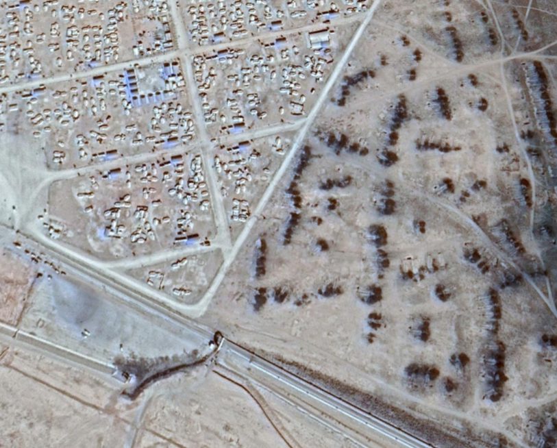
Satellite image: Arish IDP camp in Hassakeh governorate: the camp is located 70km from Deir ezZor frontline and was established in June 2017. The area used to serve as a petroleum refinery, hence toxic waste could be found on site. October 4, 2018 Maxar/Google Earth.
The workshop Effects of Armed Conflicts on Local Environments, How can Humanitarians respond, hosted by Chatham House, PAX and UNITAR at the end of the week, brought various elements of these discussions together, outlining the impact of conflicts on the environment and health of people. PAX demonstrated the pioneering use of remote sensing in monitoring of conflicts based on its case studies from Iraq and Syria, while Chatham House demonstrated how innovative techniques can be applied to conflict waste to improve building back greener and better post-conflict. UNITAR outlined the application of sustainable energy use in conflict and disaster displacement settings, aiming to minimize the environmental footprint and improve health conditions of affected populations.
Over the last couple of years, PAX has actively participated at the HNPW through presentations and workshops on environmental monitoring of armed conflicts and by demonstrating how remote sensing and open-source investigation can support humanitarian response. This edition of the HNPW demonstrated that there is a clear need for increased and better information sharing and analysis on environmental issues considering the consequences on humanitarian operations and their target groups in affected areas. Therefore, the growing attention on utilizing remote sensing tools, GIS analysis and the necessity of including environmental dimensions in the humanitarian analysis during this year’s edition was very welcome. Improved collaboration on specific themes or crises, sharing environmental data and building sound and open-source methodologies will contribute to faster response in humanitarian contexts in order to save lives and minimize and prevent environmental degradation.